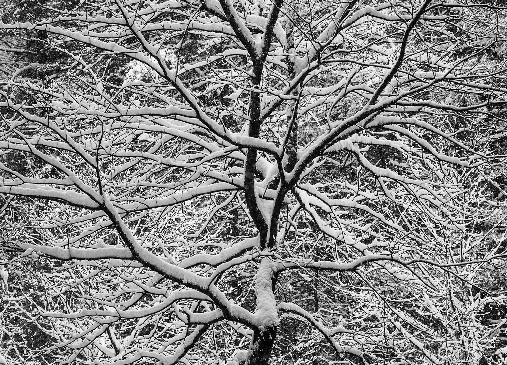
Snowfall on Stanley Creek


Tree In Snow; 2017

The snowfall started at around 4 in the morning. I know this because I went back and viewed the web camera we have mounted outside our deck that looks down on Stanley Creek.  At around 4 AM the deck was empty, by 9 AM we had about four inches. It was the sticky thick kind of snow and it went on all day. By dark, we had about 8 inches total. Snowfall in the North Georgia mountains is fickle. Most winters you get a few light dustings and maybe one or two large snowfalls. These larger snow events stop everything as the roads become impossible to navigate.

Early December snow in the North Georgia mountains. Stanley Creek is seen below near Blue Ridge, GA #theta360 – Spherical Image – RICOH THETA

360 degree image of our log home and Stanley Creek below

This would be an adventure, Though we had snow all day and power the entire time, the next morning the power went out at 9:10 AM and would not come back on for 55 hours. The inside of the cabin cooled through the second day to around 47 degrees Fahrenheit. The water inside the house slowed to a trickle as the electric pump on our well provides the water pressure for the house. We finally got out on the third day, and moved to a hotel in town until we got our power back.

Twin Firs, Snow; 2017

Throughout the first day, I made still photographs, 360 degree images and a video of our creek with the the large clumps of snow falling down from the twin 125 foot plus fir trees that are centered by our cabin.

The video was meant to be a 15 minute meditation video of the snow falling with the sound of the flowing creek below. What was unexpected was the regular unleashing of clumps of snow from the treetops above which fell with a calming ‘whoosh’  sound. For the best effect, play the video below full screen on your device – and breath deep.

Technical details: For the video I used a small 4k Sony camera that I could cover with a plastic bag. I later edited the piece on my Avid Media Composer. I have come to love the Ricoh Theta 360 degree camera. It fits in your pocket and is great while traveling to quickly capture special images.

Sony 4k video camera used in the video above

Ricoh Theta used for the 360 degree image

#Snowall #RicohTheta #video


Horseshoe Bend, Arizona

We had another incredible trip to the US Southwest in October experiencing many great new sights and revisiting a couple of ones we had been to before.

One memorable location was Horseshoe Bend, which is a horseshoe-shaped feature on the Colorado River about five miles south of Glen Canyon Dam near the town of Page, Arizona.

This location is one of the most photographed areas in Arizona, and is well-known by photographers across the world. At this point in the age of photography, it is hard to capture something new at this place, but it is definitely worth the visit.

We had planned to go here from the start of our Southwestern trip and wanted to have opportunities to photograph it at sunset as well as late-morning light. Arriving about an hour before sunset, we had to circle the dusty parking lot several times, proudly collecting layers of dust on our car like a badge of honor, amidst a throng of dusty vehicles and people.

Following the ‘herd’ to Horseshoe Bend

From the parking lot, it was a true madhouse swarm of people hiking, running, and limping up and down the trail to the canyons edge. All ages, nationalities, shapes and sizes of folk, along with all varieties of their kids running all about, as well as their dogs who also came in all shapes and sizes. The sun was on its way to setting, so everyone was in a hurry to see where the heck it was going.

All lined up at the edge

It bares mentioning at this point, that most all of the kids and dogs were not on leashes. You approach the overlook by hiking a mostly sandy 3/4 mile trail to the edge, which is a shear drop of 1000 feet to the river below – without any guardrails! I got to the edge, which was lined with people, including lots of other photographers who had staked their claim to the edge with their tripods. It was crazy to see all the kids and animals running around unattended so close to a shear 1000 foot drop.

1000 foot drop is not for the faint of heart

Now a word about heights – I have a touch of vertigo, but my wife is so scared of heights she was actually in Vertigo. At Horseshoe Bend, she couldn’t get any closer than the parking lot 3/4 of a mile away – actually, I made that up – she was able to tolerate leaning over to look from about twenty feet from the edge. She had been a trooper thru much of the trip to the ‘Grand Canyon’ region – which, translates from Native American to, ‘Many vantage points to look down into large hole from great height’.

Here’s my GoPro Image

My goal was to get a good black and white image and also something in color using my GoPro, which has a lens so wide angle, it sometimes seems you actually can see ‘behind’ the camera. I made my images by holding my Nikon over the head of the guy sitting next to his tripod with his feet dangling over the edge. My GoPro color shot was made the same way using a selfie stick fully extended over the heads of the ‘edge people’. The closest I could get was four or five feet from the edge, which was close enough for me!

I must say the ‘no guardrail’ thing is probably going to change soon. There is new construction going on that will probably make it safer. In an attempt to limit the amount of people getting uncomfortably close to a thousand foot free-fall, they are designing a viewing platform on the edge to accommodate the masses. Also, to disclaim, fortunately no one fell over the edge and no animals or children where injured in the making of these images. I just wonder how often that does happen!

#HorseshoeBend #Arizona


Sailing on Shiprock

Shiprock, NM – 2012

Often when I am traveling, I will see something that will make for a compelling image but the conditions are not quite right. I have developed a habit of filing the potential photo opportunities into my iPhone for a possible return in the future. Shiprock was one of these. I have been though this area many times, but the light was never quite right for the images I wanted to make of this remarkable landmark.

The Shiprock  volcanic geological formation is located in Four Corners, NM. The peak is about 1700 feet (482 meters) above the surrounding plains, though originally the structure was 2500-3000 feet (750-1000 meters) in height. Erosion has left us with what we see today, which is the frozen lava core of the volcanic structure. Also interesting are the wings or ‘dikes’ that radiate to the south of the central peak which are also volcanic rock frozen in time.

The Navajo call this formation Tsé Bitʼaʼí, “rock with wings” or “winged rock”. It has deep cultural significance to the Navajo people. Since these images were made in 2012, all areas of the formation are off limits to the general public. Though I have heard you can photograph the structure from three miles away, which is approximately where I made these images from.

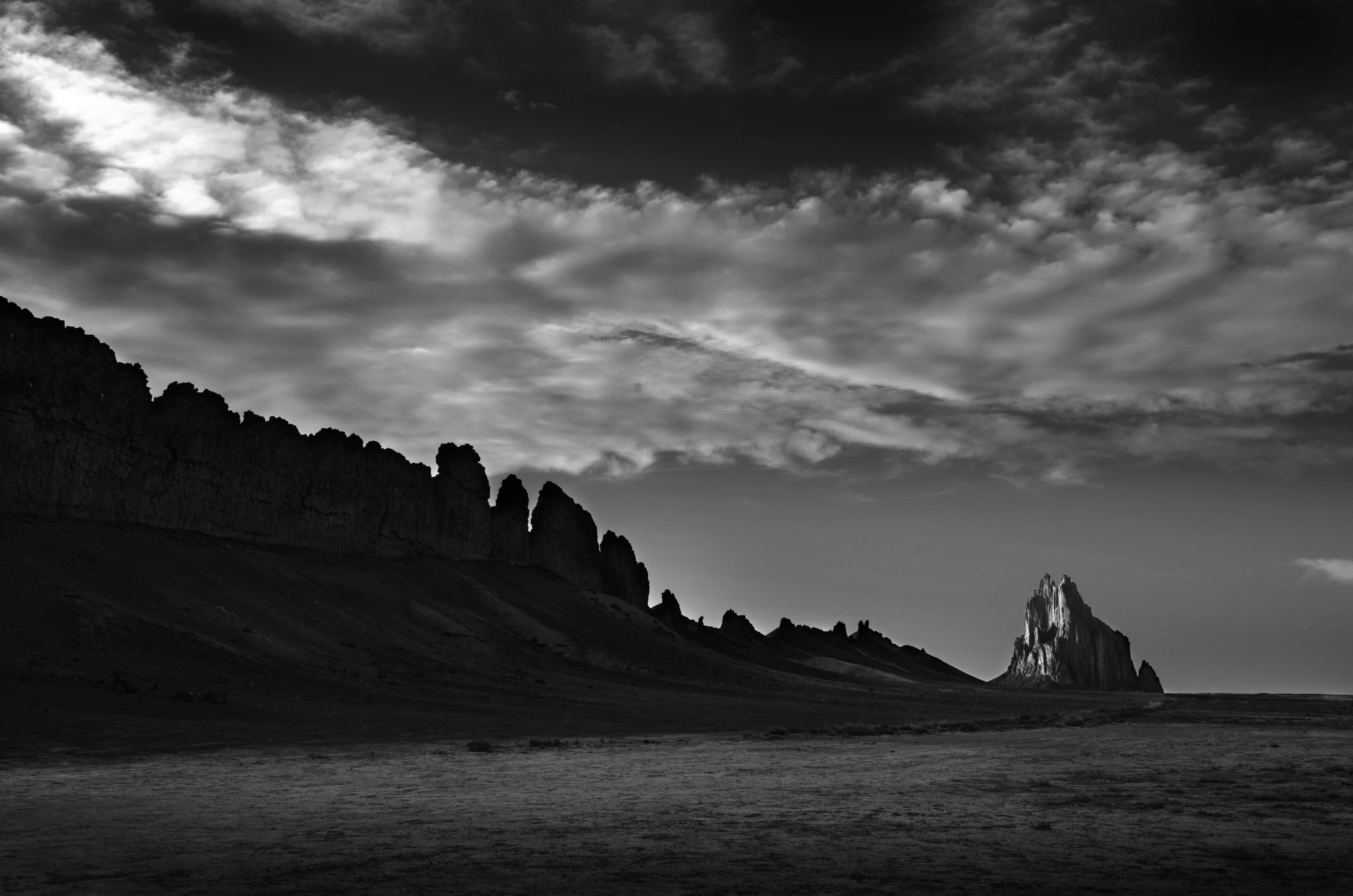
27 million year old geological ‘wings’ of frozen lava

I knew I wanted to photograph this structure in the late afternoon as the sun was setting. That day I travelled from Kenab, UT and spent some time shooting in Monument Valley timing myself to arrive here about two hours before sunset.

Thunderstorms building to the east

As I arrived at Shiprock, thunderstorms began to build on the open plains to the east and they were moving towards where I was.  This could be either really good, or really bad. Turns out it was really good. The thunderstorms pushed some interesting clouds westward which in turn were being lit by the sun as it set.

Cloud formations pushed in by the approaching thunderstorms

After the sun set, the storms moved in and I was pelted with hail and heavy rains on my way to Farmington, NM for the night. BTW, when in Farmington, I highly recommend the Three Rivers Restaurant and Brewery, which was the perfect way I ended this remarkable photographic day.

#shiprock